Foto 1 di 6


Galleria
Foto 1 di 6


Ne hai uno da vendere?
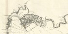
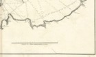
Mappa "Plano de la Ría y Puerto de Ferrol" (Spagna) Dirección de Hidrografía, 1789-

GBP 400,00
CircaEUR 461,18
o Proposta d'acquisto
Condizione:
- Compralo SubitoMappa "Plano de la Ría y Puerto de Ferrol" (Spagna) Dirección de Hidrografía, 1789
Oops! Looks like we're having trouble connecting to our server.
Refresh your browser window to try again.
Spedizione:
GBP 18,00 (circa EUR 20,75) International Tracked Postage.
Oggetto che si trova a: London, Regno Unito
Consegna:
Consegna prevista tra il lun 15 set e il mar 30 set a 94104
Restituzioni:
Restituzioni non accettate.
Pagamenti:
Fai shopping in tutta sicurezza
Il venditore si assume la piena responsabilità della messa in vendita dell'oggetto.
Numero oggetto eBay:335877683533
Specifiche dell'oggetto
- Date Range
- 1700-1799
- Antique
- Yes
- Type
- Nautical Map
- Format
- Sheet Map
- Year
- 1789
- Era
- 1700s
- Cartographer/Publisher
- Brigadier Vicente Tofiño de San Miguel / Dirección de Hidrografía
- Original/Reproduction
- Antique Original
- City
- Ferrol
- Country/Region
- Spain
Descrizione dell'oggetto fatta dal venditore
Informazioni sul venditore professionale
CRN: 07952137
Informazioni su questo venditore

map2map
100% di Feedback positivi•732 oggetti venduti
Registrato come venditore professionale
Categorie più popolari di questo Negozio
Feedback sul venditore (314)
- e***2 (1305)- Feedback lasciato dall'acquirente.Ultimi 6 mesiAcquisto verificatoExquisite 18th century depiction and gravure of the legendary Bastille by one of the greatest artists of the period and the engraver. Offered at a price point which was generous and more than affordable. This gravure was professionally, expertly packaged—which is a distinct pleasure. It is always pleasing to deal with a professional business in antiquities, as they possess the knowledge in handling fragile, irreplaceable, historical art. Sent securely by Fedex, arriving very quickly. RecommendedAntique Print "A View of the Bastile at Paris" (Bastille) Rigaud, 1749 (N° 335814097225)
- f***5 (5)- Feedback lasciato dall'acquirente.Ultimi 6 mesiAcquisto verificatoQuickly shipped, very well packaged with supporting internal card and plastic. As described and in good condition. Thank you once more. Comes once more with a certificate of authenticity, which is very much appreciated. This is my second map from this gallery and probably won't be the last. Highly recommended.Map "Southern Alps of New Zealand" Royal Geographical Society, 1910 (N° 334963326798)
- u***i (151)- Feedback lasciato dall'acquirente.Ultimi 6 mesiAcquisto verificatoItem as described. Packed well with fast shipping. In good condition for its age! Would buy from this seller again.Antique Map "Carta delle Isole Pelew" (Palau/Philippines) Anon, c.1790 (N° 335166770898)