Foto 1 di 3


Galleria
Foto 1 di 3


Ne hai uno da vendere?
Then and Now Bible Maps: Compare Bible Times with Modern Day - BRAND NEW!!

US $4,72
CircaEUR 4,06
o Proposta d'acquisto
Prezzo iniziale: US $5,55 (15% di sconto)
Condizione:
Nuovo
Libro nuovo, intatto e non letto, in perfette condizioni, senza pagine mancanti o danneggiate. Per maggiori dettagli, consulta l'inserzione del venditore.
La vendita promozionale scade tra: 5g 12h
- Compralo SubitoThen and Now Bible Maps: Compare Bible Times with Modern Day - BRAND NEW!!
Oops! Looks like we're having trouble connecting to our server.
Refresh your browser window to try again.
Ritiro:
Ritiro gratuito dell'oggetto in zona da Byron Center, Michigan, Stati Uniti.
Spedizione:
US $1,36 (circa EUR 1,17) USPS First Class Letter .
Oggetto che si trova a: Byron Center, Michigan, Stati Uniti
Consegna:
Consegna prevista tra il mer 23 lug e il mar 29 lug a 94104
Restituzioni:
Restituzioni non accettate.
Pagamenti:
Fai shopping in tutta sicurezza
Il venditore si assume la piena responsabilità della messa in vendita dell'oggetto.
Numero oggetto eBay:286691115927
Specifiche dell'oggetto
- Condizione
- Literary Movement
- Modernism
- Signed
- No
- Narrative Type
- Nonfiction
- ISBN
- 9781596361300
Informazioni su questo prodotto
Product Identifiers
Publisher
Rose Publishing
ISBN-10
1596361301
ISBN-13
9781596361300
eBay Product ID (ePID)
120277395
Product Key Features
Book Title
Then and Now Bibles Maps : Compare Bibles Times with Modern Day
Number of Pages
2 Pages
Language
English
Publication Year
2007
Topic
Biblical Reference / Atlases
Genre
Religion
Format
Paperback
Dimensions
Item Height
0.1 in
Item Weight
1.1 Oz
Item Length
8.6 in
Item Width
5.6 in
Additional Product Features
Intended Audience
Trade
Dewey Decimal
220.91
Synopsis
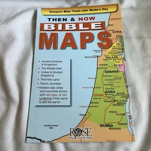
Easily see where Bible places are located today with this slimline pamphlet that fits in most Bible covers! Then and Now Bible Maps pamphlet includes 17 maps showing biblical cities and countries in black and modern-day map boundaries in red. These bright, colorful Bible maps cover the major biblical areas: Canaan, Assyria, Babylon, Egypt, Paul's Journeys to Rome, and the land given to the 12 tribes of Israel. The Then and Now Bible Maps pamphlet is a fantastic Bible study tool. 14 panels, fits inside most Bibles, 8.5 x 5.5 inches, unfolds to 38 inches long Most Convenient Bible Maps on the Market! Most Bibles only include maps that are black and white and show the location of Bible places in small print. Imagine having 17 full-color maps that not only show the location of Bible places--but where they would be located today! This slimline, fold-out format ensures you'll never have to flip back and forth!Covering all major areas mentioned in the Bible, such as Canaan, Babylon, and the Holy Land, this incredible pamphlet helps put Bible stories in context by including modern-day cities and countries in red. Features include easy-to-read print, clear graphics, vivid colors, and more! Easily See Where New and Old Testament People Lived and Events Took Place Then and Now Bible Maps pamphlet makes it easy to compare Bible times with modern times. On each of the 17 maps, modern-day cities and countries appear in red type (or red underline if the name has remained the same.) Then and Now Bible Maps provides helpful historic information, such as: The Holy Land: Then (1300 BC Twelve Tribes) and Now (modern times) uses color coding to show Canaan divided by the Twelve Tribes, and also shows the historical and modern-day names of cities Paul's Journeys: Then (AD 47-62) and Now (modern times) shows the locations of the Seven Churches of Asia (modern day Turkey) Empires and Kingdoms: Then and Now shows the changing boundaries of the Assyrian Empire, Babylonian Kingdom, and Persian Empire You will refer to the Then and Now Bible Maps pamphlet often to see: The Middle East Bible Times and Today The Holy Land: Then (1300 BC Twelve Tribes) and Now (Modern Times) Empires and Kingdoms: Then and Now The Holy Land: 1020 BC and 900 BC Places of Jesus' Ministry Then (AD 26-30) and Now The Holy Land: Then (New Testament Times AD 1-70) and Now (Modern Times) Paul's Journeys: Then (AD 47-62) and Now (Modern Times) Paul's Journeys: AD 47-62 Paul's Second Journey: AD 49-51 Paul's Third Journey: AD 52-57 Paul's Journey to Rome: AD 57-62 You will find Then and Now Bible Maps is a very useful supplement as you learn more about the Scriptures."Where is this Bible place today?" Then and Now Bible Maps will help you better understand the events and stories in the Bible by showing you where they occurred in comparison to modern day locations. Your Bible study becomes more meaningful when you learn the location of Old Testament Persia and see the places Paul's first missionary journey would take him if traveling the same route today. You will also better understand the biblical context of the places that are in the news every day, like Syria, Lebanon, and Macedonia., Easily see where Bible places are located today with this slimline pamphlet that fits in most Bible covers! Then and Now(R) Bible Map Pamphlet includes 17 maps showing biblical cities and countries in black and modern-day map boundaries in red. These bright, colorful Bible maps are affordable and have large print. They cover the major biblical areas: Canaan, Assyria, Babylon, Egypt, Paul's Journeys to Rome, and the land given to the 12 tribes of Israel. The Then & Now(R) Bible Map Pamphlet is a fantastic Bible study tool. 14 panels, fits inside most Bibles, 8.5 x 5.5 inches, unfolds to 38 inches long Most Convenient Bible Maps on the Market! Most Bibles only include maps that are black and white and show the location of Bible places in small print. Imagine having 17 full-color maps that not only show the location of Bible places-- but where they would be located today! This slim-line, fold-out format ensures you'll never have to flip back and forth!Covering all major areas mentioned in the Bible, such as Canaan, Babylon, and the Holy Land, this incredible pamphlet helps put Bible stories in context by including modern-day cities and countries in red. Features easy-to-read print, clear graphics, vivid colors, and more! Fits inside most Bible covers, making it easy to reference during personal or group Bible studies. Easily See Where New and Old Testament People Lived and Events Took Place Then & Now(R) Bible Maps pamphlet makes it easy to compare Bible times with modern times. On each of the 17 maps, modern-day cities and countries appear in red type or red underline if the name has remained the same. Then & Now(R) Bible Maps provides helpful historic information, such as: The Holy Land: Then (1300 BC Twelve Tribes) and Now (modern times) uses color coding to show Canaan divided by the Twelve Tribes, and also shows the historical and modern-day names of cities Paul's Journeys: Then (AD 47-62) and Now (modern times) shows the locations of the Seven Churches of Asia (modern day Turkey) Empires & Kingdoms: Then and Now(R) shows the changing boundaries of the Assyrian Empire, Babylonian Kingdom, and Persian Empire You will refer to the Then & Now(R) Bible Maps pamphlet often to see: The Middle East Bible Times and Today The Holy Land: Then (1300 BC Twelve Tribes) and Now (Modern Times) Empires & Kingdoms: Then and Now(R) The Holy Land: 1020 BC and 900 BC Places of Jesus' Ministry Then (AD 26-30) and Now The Holy Land: Then (New Testament Times AD 1-70) and Now (Modern Times) Paul's Journeys: Then (AD 47-62) and Now (Modern Times) Paul's Journeys: AD 47-62 Paul's Second Journey: AD 49-51 Paul's Third Journey: AD 52-57 Paul's Journey to Rome: AD 57-62 You will find Then & Now(R) Bible Maps is a very useful supplement as you learn more about the Scriptures. " Where is this Bible place today? " Then & Now(R) Bible Maps will help you better understand the events and stories in the Bible by showing you where they occurred in comparison to modern day locations. Your Bible study becomes more meaningful when you learn the location of Old Testament Persia and see the places Paul's first missionary journey would take him if traveling the same route today. You will also better understand the biblical context of the places that are in the news every day, like Syria, Lebanon, and Macedonia., Where are the Bible lands today? Where were Iraq and Iran in Bible times? The answers to these questions and countless others are found in the bestselling pamphlet Then & Now Bible Maps. This full-color, fold-out reference tool contains 17 Bible maps that show ancient cities and countries in black with modern-day boundaries marked in red. Fantastic for comparing places in the news with places in the Bible. Size: 8.5x 5.5 unfolds to 38 long. Fits inside most Bible covers. Teachers love the amazing Then & Now Bible Maps reference tool. Seventeen maps make the Bible more relevant and more meaningful by providing visual context. Show students where Persia is today and the places Paul's first missionary journey would take him if traveling the same route today. Help them understand the biblical geographic context of the places they hear in the news every day. Here are a few of the maps included in this incredible resource: The Middle East map during Bible Times and Today The Assyrian Empire, Babylonian Kingdoms and Persian Empire The Holy Land Map Then and Now Places of Jesus' Ministry Then and Now Then & Now Bible Maps pamphlet makes it easy to compare Bible times with modern times. On each of the 17 maps, modern-day cities and countries appear in red type or red underline if the name has remained the same. The maps provide helpful historic information. For example: The Holy Land: Then (1300 BC--Twelve Tribes) and Now (modern times) uses color coding to show Canaan divided by the Twelve Tribes, and also shows the historical and modern-day names of cities within the regions occupied by the Twelve Tribes Paul's Journeys: Then (AD 47-62) and Now (modern times) show one of the SevenChurches of Asia (Rev. 1-3), cities, towns, ancient ruins, mountains, modern capital cities and a key for measuring the distance traveled from city to city Empires & Kingdoms: Then and Now shows the changing boundaries of the Assyrian Empire, Babylonian Kingdom, and Persian Empire, Where are the Bible lands today? Where were Iraq and Iran in Bible times? The answers to these questions and countless others are found in the bestselling pamphletThen & Now Bible Maps.This full-color, fold-out reference tool contains 17 Bible maps that show ancient cities and countries in black with modern-day boundaries marked in red. Fantastic for comparing places in the news with places in the Bible.Size: 8.5"x 5.5" unfolds to 38" long. Fits inside most Bible covers.
Descrizione dell'oggetto fatta dal venditore
Informazioni su questo venditore

markjoseph125
100% di Feedback positivi•11 mila oggetti venduti
Registrato come venditore privatoPertanto non si applicano i diritti dei consumatori derivanti dalla normativa europea. La Garanzia cliente eBay è comunque applicabile alla maggior parte degli acquisti. Scopri di piùScopri di più
Categorie più popolari di questo Negozio
Feedback sul venditore (4.784)
- h***_ (160)- Feedback lasciato dall'acquirente.Ultimi 6 mesiAcquisto verificatoExcellent! Just as described. Great communication, helpful seller. Packaged well, fast shipping time! Thank you!
- n***e (412)- Feedback lasciato dall'acquirente.Mese scorsoAcquisto verificatoHeh heh heh… Fast shipping’, stranger. Packed like a treasure chest. Just as described, aye. A steal of a price, if I do say so meself. May fortune follow ya, wherever ya roam…
- l***o (2321)- Feedback lasciato dall'acquirente.Mese scorsoAcquisto verificatoI can’t believe how quickly this set arrived! It was accurately described, packed with great care, and shipped promptly. I am delighted and highly recommend this seller.
Vedi altro:
- Libri antichi e da collezione, tema letteratura moderna,
- Narrativa per bambini e ragazzi, tema letteratura moderna,
- Libri antichi e da collezione, tema letteratura moderna in italiano,
- Libri antichi e da collezione, tema letteratura moderna in francese,
- Libri antichi e da collezione beige, tema letteratura moderna,
- Libri antichi e da collezione copertine rigide, tema letteratura moderna
markjoseph125
100% di Feedback positivi•11 mila oggetti venduti
Registrato come venditore privatoPertanto non si applicano i diritti dei consumatori derivanti dalla normativa europea. La Garanzia cliente eBay è comunque applicabile alla maggior parte degli acquisti. Scopri di piùScopri di più
Categorie più popolari di questo Negozio
Feedback sul venditore (4.784)
- h***_ (160)- Feedback lasciato dall'acquirente.Ultimi 6 mesiAcquisto verificatoExcellent! Just as described. Great communication, helpful seller. Packaged well, fast shipping time! Thank you!
- n***e (412)- Feedback lasciato dall'acquirente.Mese scorsoAcquisto verificatoHeh heh heh… Fast shipping’, stranger. Packed like a treasure chest. Just as described, aye. A steal of a price, if I do say so meself. May fortune follow ya, wherever ya roam…
- l***o (2321)- Feedback lasciato dall'acquirente.Mese scorsoAcquisto verificatoI can’t believe how quickly this set arrived! It was accurately described, packed with great care, and shipped promptly. I am delighted and highly recommend this seller.